Tethys on this blog has mostly been used to refer to the ancient ocean which used to run between the southern and northern continental blocks of Gondwanaland and Laurasia, which finally closed when the Mediterranean formed, all that’s left of it today really, and North and South America collided. Up until that point, an ocean had run right round the world, a little like the Southern Ocean today but near the tropics, which therefore had a powerful circular current and perhaps also strong winds. It would’ve allowed sail boats to navigate and travel quite easily around the planet, so in a way it’s a shame it ceased to be while we were still living in the trees, but maybe not.
The reason it was called Tethys stems from the fact that today’s Atlantic Ocean was named after the titan Atlas. Tethys the titan married her brother Okeanos, who was a vast river encircling the world. Tethys herself, although a mythical figure, has hardly any mythology attached to her. She’s more like Britannia, a mere symbol, in this case for the sea, and there is a further ancient ocean named after her brother Iapetus. She’s also the mother of the sea nymphs, the Oceanids, and numerous river deities. It’s a shame she didn’t do anything really.
The moons of Saturn are of course often named after titans, apart from the one which is actually called Titan, which is a bit weird really, but then most people call Cynthia (Selene, Diana, Artemis) “the Moon”, so Earth’s not much better. Tethys the moon is the innermost large moon of Saturn with a diameter of 1 050 kilometres, and is the second brightest moon per unit area after Enceladus. It’s also practically a twin of the next moon out, Dione, in terms of size. Both moons are in similar orbital resonance relationships with Mimas and Enceladus respectively, which needs some explaining because Mimas is quiet and cold inside whereas Iapetus is quite active and heated, apparently by tidal forces from Dione. Tethys is accompanied in its orbit by two trojan moons each forming the points of an equilateral triangle with it and Saturn, called Telesto and Calypso, Telesto being the leading member of the pair. Calypso is slightly larger but both are roughly the size of the Isle of Wight. Remarkably, even though both were discovered in 1980, it wasn’t the Voyager probes what did it, but telescopes on Earth. They were originally known as Tethys B and C. I didn’t know about them at the time, although I did know about Dione B, which is another story.
As befits a moon in orbital resonance with Mimas, Tethys too has a proportionately enormous impact basin. Since it’s more than twice the diameter of the inner moon, Odysseus, the crater, is itself four hundred kilometres in diameter, which is larger than the whole of Mimas and forty percent of the diameter of Tethys, making it proportionately the biggest crater that actually still looks like one on any moon. Unlike Herschel on Mimas, the floor of the crater does conform to the spheroidal shape of the moon, meaning that it has little influence on the distance to the horizon. The floor is three kilometres below the mean radius and the rim five kilometres above it, making the edge of the crater almost as high as Mount Everest above sea level, except that in the case of the mountain it rises from a plateau and would therefore not appear to be anything like as high. Nepal is on average already three kilometres above sea level. Moreover, this is a ring around 1 260 kilometres in circumference. In the centre of the crater is a plateau called Scheria Montes around three kilometres high with a basin in its own centre. There are faults around the rim, of which the largest is called Ogygia Chasma.
Even though the proportions of the craters to the moons are similar in both cases, it’s not Tethys but Mimas which has been called the Death Star Moon. This is because Herschel on the latter is relatively speaking a deeper dent than Odysseus. When I first came across Tethys, I’d just been impressed by Herschel’s size, so I was amazed that this second crater was bigger than the whole of Mimas and it is initially puzzling that it’s Mimas which gets all the kudos, but the reason is that Odysseus is smoother and flatter. However, Herschel is centred on the Mimantean equator whereas Odysseus is centred at around 35° north, so it’s actually off-centre in the same way as the Death Star’s depression is. It’s thought that when the crater originally formed, it was deeper but the relative softness of the surface and the higher gravity led to it being smoothed out as the millennia went by. The surface gravity on Mimas is 0.6% of Earth’s, whereas that of Tethys is more than twice that at 1.4%.
Although the gravity is greater, it was formerly thought that the crack across the middle of Tethys was a sign that the entire moon had been shattered by the impact and had fallen back together again. This is known as Ithaca Chasma, and at this point readers of the Iliad and Odyssey will have detected a theme to the names of the features: others include Polyphemus, Ajax, Circe and Penelope. Ithaca probably looks something like this:
Ithaca stretches three-quarters of the way around the world at 2 000 kilometres and is situated at a great circle centred on Odysseus and crossing both poles, interrupted by the crater Telemachus, so it might be thought that it’s connected to the giant crater, but remarkably it’s been found to be coincidental. The relative ages of features on many bodies with little to no atmosphere can be estimated by how cratered they are, and by this method Odysseus has been established to be younger than Ithaca. It was there already. I find this quite a remarkable coincidence, but a crater of that size seems to stand quite a good chance of being aligned with such a feature due to its large size. It’s 20° from the centre of the circle outlined by the chasm, and allowing for that on the surface means it would either be in the hemisphere on one side or the other of the moon from it, which doubles the probability, and allowing for 20° means the area which could be seen as the centre of the circle actually covers sixty degrees of 180, raising the probability to more than one in ten, and there are more than ten round moons orbiting Saturn so it becomes a lot less noteworthy that way. It’s an interesting demonstration of how misleading intuition regarding probability can be.
The chasm is about three kilometres deep and up to a hundred wide, though it varies a lot down to just a few kilometres. It seems to have been caused by the expansion of ice on freezing when the internal ocean froze early in the history of the moon, although it might have resulted from early tidal heating from Dione, which is in 3:2 orbital resonance with it.
The fourth-largest crater is called Penelope, and is just north of the equator about a third of the way across the globe from Odysseus, and has a diameter of two hundred kilometres. It was the second largest known crater before the whole of Tethys was mapped. It’s named after the wife of Odysseus. Away from these two craters, the terrain is quite heavily cratered with an alignment parallel to Ithaca.
It’s Enceladus which makes Tethys so bright. Ice from the geysers on the other moon hit the surface, covering it in very bright material, particularly on the leading side, which is around 12% brighter. The darker hemisphere is about the same colour as the darker of Saturn’s moons and may be high in iron. There are likely to be other constituents than water ice on or near the surface but these are hidden by the ice and so it’s difficult to tell what else is there. The regolith, i.e. the “soil”, actually ice, on Tethys, is unusual in that it’s 95% empty, kind of like polystyrene foam, a situation I imagine is helped by the low gravity and caused by the steady deposition of small particles of ice gently resting on each other over millions of years.
The moon is slightly redder and brighter near the centre of the leading hemisphere, bluer around Ithaca and somewhat darker red on the other side.
That’s about all I have to say about Tethys, which is incidentally about the same size as Ceres but otherwise quite different, being much icier. Next time, Dione.
(this is effectively a poster, if you want to download it, but it uses a lot of black ink).
Saturn and its moons are the second example of a mini-solar system within the big one. For thousands of years, Saturn was thought to be the outer limit of the Solar System, and has its own associations because of that, but for today I want to concentrate on the whole system of Saturn, with moons, rings and magnetosphere all included, rather than the planet itself.
Saturn has a prodigious number of moons, the count sometimes exceeding Jupiter’s. This is because of the Titius-Bode series. As you go further out, the orbits of the planets get more widely separated, meaning that a planet of the same mass has a longer gravitational reach over its surroundings. Saturn is of course considerably less massive than Jupiter, but its Hill Sphere, the region where its gravity is dominant, is bigger than Jupiter’s, at 1025 radii compared to Jupiter’s 687. Working this out in kilometres, Jupiter’s has a diameter of 96 million kilometres and Saturn’s is 119 million. Against this is the fact that the system is less cluttered out by Saturn than it is near Jupiter, with the asteroid belt being near the larger planet. Saturn has eighty-three moons not including the ones which form part of the rings, compared to Jupiter’s eighty. There was a point when Saturn’s moon count far exceeded Jupiter’s, but this seems to be over. The Hill Spheres are nowhere near each other and there is no competition between the two in this way. Unlike the magnetospheres.
When Voyager 2 was on its way to Saturn, it encountered Jupiter’s magnetotail in February 1981, which may indicate that the tail is forked. It did so again in May that year by which time it was nine-tenths of the way there, or around eighty million kilometres from Saturn. Saturn can even be within Jupiter’s magnetotail at times. As far as Saturn’s magnetosphere is concerned, all its moons out to Titan orbit entirely within it. Titan itself is very close to the edge and passes in and out of it, spending about a fifth of its time within. It’s surrounded by a doughnut of hydrogen extending inwards to Rhea, which is the second-largest moon. The bow shock is somewhat further out and extends north and south of the planet for at least thirty radii. Sunward it extends for almost two million kilometres. This means that of the large moons, only Iapetus and Phoebe orbit outside it entirely. As well as the neutral hydrogen torus around the orbit of Titan, there’s an inner torus of rarefied plasma of ionised hydrogen and oxygen, which effectively means protons and oxygen ions, whose outer diameter is about 400 000 kilometres. At the edge of this torus the temperature is over 400 million degrees C, but it should be born in mind that Earth’s thermosphere is 2 500°C and the Sun’s atmosphere is over a million Kelvin, which is hot but didn’t destroy the probe recently sent there. Temperature really represents the average kinetic energy of the particles and not heat. In a sauna, the air temperature can be over 100°C but the effect on the human body is nowhere near as harsh as boiling water for this reason.
Titan comprises 96% of the mass of all Saturn’s moons put together. This seems actually to be more typical than Jupiter with its four large moons, as similar mass distributions are found among the moons of Uranus and Neptune. The whole system has a kind of quietness and serenity to it, at least from afar. Some of the moons are active, but there’s nothing like the hot volcanism found on Io. All the moons are substantially icy. Saturn’s moons are unique in that some of them have trojans – moons which share their orbits but are sixty degrees behind or ahead of the larger moons. Saturn in general has quite a cluttered and ice-strewn neighbourhood in connection with its rings, and this seems to be part of this aspect of it. This means that the exact number of moons can never be determined because the size of bodies orbiting it goes all the way down, fairly evenly, to miscroscopic grains of ice and dust. In a way, all that can be said is that Titan is the biggest by far, being about the same size as Ganymede.
The five large inner moons, Mimas, Enceladus, Tethys, Dione and Rhea, all participate in the magnetosphere, absorbing protons, as do the particles making up the very sparse E ring. I’ll talk about the rings in detail when I get to Saturn itself, but another unique feature of Saturn’s system is the interaction between the particularly substantial rings and the magnetosphere. The other giant planets have much less substantial rings and therefore less significant interactions. Electrons are absorbed by the main rings, and below the main rings towards Saturn is the least radioactive region of the entire Solar System outside of large bodies and their atmospheres because the rings act as a radiation shield. There is, however, nothing as strong as the plasma tunnels and torus around Io, which influences radio transmissions from Jupiter.
Radio signals from Saturn are weaker than the ones from Jupiter in a broad range from twenty kilohertz to one megahertz, so listening to long or medium wave radio stations there would be right out. Like Jupiter’s System III, which is the common rotation of the interior of the planet with its magnetosphere, Saturn has its own System III, lasting ten hours, 34 minutes and two dozen seconds. There is nothing as strong as Io’s influence, but there is a relatively mild variation corresponding to the time taken for Dione to orbit, 2.7 days. This could be coincidence. When Saturn passes close to Jupiter’s magnetotail, the radio transmissions become undetectable but it isn’t clear whether they cease because of it or are just overwhelmed by Jovian radio noise.
The moons have fairly regularly spaced orbits out to Rhea, although there are some smaller moons which either share orbits with larger moons or regularly swap over. Titan, though, is over twice as far from Saturn as Rhea, then Hyperion is relatively close to Titan, Iapetus over twice as far from Saturn as Hyperion, and finally Phœbe is much further out and orbits backwards compared to the others and the majority of other worlds in the Solar System. This suggests that Phœbe is a captured asteroid. Surprisingly, although it was discovered in 1898, no moons further out were found until the twenty-first century despite the fact that the planet was visited several times by spacecraft. However, almost four dozen moons have now been found which orbit backwards. More than two dozen moons have yet to receive names because there are just so many of them. Even the most distant moon is well within Saturn’s Hill sphere, so it’s still possible that there are more. There’s also a cluster of moons, including shepherd moons and coörbitals, near the rings and possibly even within them, but it should be borne in mind that there’s a judgement call here regarding how big a ring particle is before it counts as a moon or moonlet.
Saturn, and therefore its system to some extent, is tilted 27° with respect to its orbit. This also tilts some of the moons but others are already at odd angles and it’s fairly meaningless to regard them as influenced by this tilt. For Dermott’s Law, mentioned in connection with the Galileans a couple of days ago, T=0.462 days and C=1.59.
I’m going to end on a personal note. I don’t remember Kepler’s third law of planetary motion very clearly, so I always use Saturn to work it out. Saturn is about ten AU from the Sun, i.e. ten times Earth’s distance. The cube of this is a thousand, and that’s square root is thirty. Saturn takes thirty years to orbit the Sun once, hence the Saturn Return of astrology, meaning that the cube of the semimajor axis (average distance from the Sun) of a planet is directly proportional to the square of its sidereal period (“year”).
Next time I’ll be looking at Saturn itself, including its rings, the famous hexagon and the unexpected connection with a certain comedian.
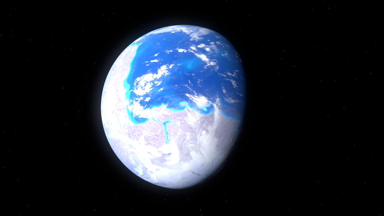
This is a map of the world as it was at the start of the Late Cretaceous Period. Although the Cretaceous is primarily associated with being the last period of non-avian dinosaur dominance, and eventually the arrival of the Chicxulub Impactor near Yucatan, it has another distinctive feature which is less often mentioned. The name “Cretaceous” derives from the Latin creta, meaning “chalk”, because it’s associated with extensive chalk and other limestone deposits. This is because foraminifera, protozoa with calcium carbonate shells, fell constantly onto the ocean floor, laying down what would become chalk, and, not to let foraminifera alone get the spotlight, there were also radiolaria, similar protozoa with silica exoskeletons, raining down and becoming flint. Neither set of organisms was new to the Cretaceous, but they’re particularly widespread in Cretaceous sediments because so much of what is now land was underwater at that time. Oceans covered a maximum of eighty-two percent of the planet’s surface during this period, meaning that there was only sixty-two percent as much land as there is today. Another distinctive feature of this time, which partly follows from that, is that much more of the water was in the form of shallow seas, all the light blue on the above map. Today the shallow seas are quite fragmented and not particularly extensive. They consist of the waters around Britain, the Red Sea, the Caribbean, the Persian Gulf, Indonesia, Hudson Bay, eastern Eurasia, some of the Med and not much else, although the Arctic is rather shallow but atypical due to being icy. Today’s shallow seas are also quite new, because many of them have only been flooded since the end of the last Ice Age or more recently, and being disconnected from each other don’t form particularly large biomes. By contrast, in the Jurassic and Cretaceous, particularly later on, something like an eighth of the water-covered surface of our planet was in this condition and much of it was also interconnected. This is for two reasons. One is that there were no permanent ice caps, so sea level was at least ninety metres higher – actually higher than that because of the thermal expansion of the warmer water. The other was that much of the land which is now mountain ranges had not only not yet become those ranges but hadn’t even got above sea level yet, although it was on its way to doing so. From the map, it can be seen that there are no Alps or Himalayas, but the surface which became those is not far underwater and has yet to be folded, therefore occupying a larger area. Besides that, in particular the future Sahara is submarine, the future Europe consists mainly of islands and the sea and the area east of the Rockies in North America is a sea referred to as the Western Interior Seaway, all of which is shallow. Since that’s quite an awkward name, it’s also referred to as the Niobraran Sea, which is how I’m going to call it.
With the mention of the Niobraran Sea, the question might arise of what distinguishes a sea from an ocean. The Niobraran had a maximum area of around three million square kilometres, which is a sixth larger than the Mediterranean. The Med is clearly bordered today by the Straits of Gibraltar and is easy to think of as a separate, smaller body of water than an ocean, but the Niobraran was more like the German Ocean (“North Sea”) in that it was open to the wider ocean, in its case at both ends. Seas are usually thought of as nearer land and smaller than oceans, and the Niobraran, big though it was, was still less than a quarter the area of today’s Arctic Ocean. Their proximity to land would generally also make them shallower but not always. In a way, in talking about prehistoric seas and oceans at all we’re imposing our own ideas on a world which was very different. Although the distinction we make today attempts to project an order which is more blurred in reality, that doesn’t mean that oceans and seas are not natural kinds. Making this assumption though, the underwater world of the Cretaceous is still geographically very different to our own because rather than consisting of much smaller shallow bodies of water and larger deeper bodies which could be called seas and oceans, its world includes vast seas as well as vast oceans. That said, the Pacific was still by far the largest ocean, and was in fact larger than it is now because the Atlantic was just forming and the continents were closer together.
All that said, there is on this map a body of water which would have made it possible to circumnavigate the globe without leaving the tropics. The future Isthmus of Panama is absent, the Mediterranean has yet to form, India is still near Antarctica and so is Australia, and then there’s the Pacific, which is already in existence. This is what is variously known as the Tethys Ocean and Tethys Sea, and at this point I will pause to consider the naming of ancient seas and oceans.
The Atlantic is named after the Atlas Mountains, which are in turn named after the Titan Atlas, who holds up the sky according to Greek mythology. The word “atlas” also refers to the first cervical vertebra, and the joint between the first and second, the axis, is called the atlanto-axial joint, indicating the unusual way in which the word “atlas” is inflected. Atlantis is also named after Atlas of course. Several of lost oceans are also named after titans, by analogy with Atlas. To an astronomically-tuned ear, this sounds rather odd because so are many of the moons of Saturn, but in any case they are the Tethys, after Τεθυς, goddess of the primal font providing Earth’s water, the Iapetus, named after Ἰαπετός, the father of Atlas because the Iapetus is the forerunner of the Atlantic Ocean, and the Rheic, after Ῥεία, sister of Ἰαπετός.
I’ll start with the Tethys. The Tethys began as a gulf on the eastern side of Pangæa in the Permian period:
(This is actually a map of the early Triassic world). The Tethys Sea (at this point) is the light blue area just northeast of the centre. It’s likely that because of the extreme climatic conditions on Pangæa, temperatures were high enough to render the Paleo-Tethys, as it’s called at this stage, quite saline due to evaporation. The existence of a single continent more or less implies the existence of a single ocean, the World Ocean, which is referred to as Panthalassa, which would have covered around seventy-one percent of Earth, or 510 million square kilometres. This is thrice the size of the Pacific, and it included the Pacific too, since the Pacific is that bit of the planet’s surface which has its own continental plate but no continent. Just as the Solar System has been said to consist of the Sun, Jupiter and assorted débris, it could equally be said that the surface of the Earth consists of the Pacific Ocean plus a bit of land and some other oceans, and this was already true back then. The Panthalassa, also known as the Panthalassic or Panthalassian Ocean, formed 280 million years ago at the end of the Carboniferous. Sea levels would’ve been fairly low at the time because there was an ice age going on in the Southern Hemisphere. Here’s a map of the world centred on Panthalassa with modern coastlines:
The borders show the edges of the continental plates, which are however devoid of land masses here in three cases. The western part of the ocean has large islands at this point. The fact that it occupies more than an entire hemisphere and is on both sides of the Equator gives it a fairly simple set of ocean currents, one northern and one southern, but it also has a temperature gradient and is coolest in the east and warmest in the west, with cold water upwelling along the east coast (i.e. the west coast of Pangæa). Panthalassa is an example of a superocean, as it surrounds a supercontinent, although it can also be defined as any ocean larger than the Pacific. Mirovoi was the ocean surrounding Rodinia, which existed between an æon and 750 million years ago:
Mirovia existed during the extreme Cryogenian Ice Age, and may have been frozen to a depth of two kilometres, although only shortly before it ceased to be.
In general, superoceans are distinguished by extremely large waves with considerable destructive power when they finally break on land and tend to be wamer in the west than the east because of the Sun warming them in a fairly simple way. They may also have had powerful monsoons. Another known superocean was the Pan-African, which surrounded the supercontinent Pannotia 600 million years ago, around the time the first animals with hard parts evolved:
This superocean closed before the start of the Cambrian and was replaced by what would become Panthalassa. It can be seen from this globe that there is no plant life visible on land yet. A new superocean and supercontinent are due to form in about 200 million years.
Returning to the subject of the Tethys, this has an established detailed history which came to an end only fairly recently in geological terms. Eurasia today still shows traces of where it used to be. The Mediterranean and Black Seas, for example, were both part of it. Just a little further east lies the Caspian, which unusually for a lake, possibly even uniquely, has oceanic rather than continental crust under it, because it was once part of that ocean. Further east still are the dying Sea of Aral and Lake Baikal, the world’s largest body of freshwater though not its largest freshwater lake by area, which is Lake Superior in North America. All of these used to be joined together and connected to the sea, and were cut off by the ongoing collision of Afrika with western Eurasia and of India with southern Asia. Before that, it was the Ceno-Tethys, the last phase of that ocean.
Supercontinents break up because magma wells up beneath them and pushes the plates apart. One example of this which happened on the southern coast of the Tethys Sea when it was little more than a giant bay was the emergence of the continent of Cimmeria, a long, thin continental mass which was often broken up into islands. This moved north and collided with part of the future Asia, and this is taken as the division between the Palæo-Tethys and the Neo-Tethys, meaning that for a while they coëxisted. This continent has now become a series of mountain ranges including, among others, the Pyrenees, Alps, Caucasus and Himalayas. For some time during the history of the Neo-Tethys, Europe, known at this stage as the Para-Tethys, had yet to become a continent and consisted of an archipelago, including the famous Haţeg Island with its giant pterodactyls feasting on pygmy sauropod dinosaurs, though that was gone by the middle of the Palæogene Period after the Chicxulub Impact. The dinosaurs and pterosaurs were gone a lot sooner than that of course. The Tethys can also be divided into eastern and western halves, separated by a narrower channel between Laurasia and Gondwanaland:
The thin isthmus between Afrika and Laurasia in the middle of that map would part, forming a seaway stretching right round the tropics. This would have had a longitudinal current flowing round much of the world. The Tethys was also full of reefs, formed not from coral but rudist bivalves, who were vertically oriented conical pipe-shaped animals who died out at the end of the Cretaceous. It probably hasn’t escaped your attention that I’m rather fixated on the Tethys. I don’t really know why, but I like to imagine a kind of vastly extended Mediterranean with its characteristic human culture, which is utterly absurd because humans didn’t evolve until after it ceased to exist. The Tethys would also have rendered the Suez and Panama Canals redundant. This would’ve been a world where it was possible to sail all the way from Southeast Asia to Columbia without having to venture far from shore. In a way, although we are creatures of our time, it sometimes seems a shame we hadn’t evolved when this was feasible. On the other hand, knowing us it would also have facilitated a lot of naval battles.
The Iapetus Ocean is another that tends to spring to mind. In a way, the Iapetus was like the Arctic in that it was a polar ocean, but in the Southern Hemisphere and not as closed in by land. Iapetus was the father of Atlas in Greek mythology, and although a lot has happened since then to scramble the jigsaw pieces, the lands bordering it are similar to those bordering the Atlantic today, hence the name. This is the “father” of the Atlantic. The ocean was detected when it was noted that bottom-living trilobites in Scotland and parts of America were similar but those in Southern England were different, suggesting that they had been separated by something, which at the time was thought to be a trench. The ocean existed from around the time of the first trilobites until 420 million years ago, and mixing of the trilobite fossils increases as time goes by and the ocean closes to form Laurasia, a component of the later Pangæa.
Then there’s the Rheic Ocean, once again an ocean named after a Titan. This was the water between the two major components of Pangæa before the supercontinent was formed, namely Laurasia in the north and Gondwanaland in the south. It formed in the late Cambrian, reached its maximum size of four thousand kilometres across in the Silurian and closed as Pangæa was forming. The Rheic was probably gone by the the enormous injection of carbon dioxide into the atmosphere from volcanoes in Siberia acidified the oceans and killed 96% of all life underwater and seventy percent above it. It closed in the late Devonian and Early Carboniferous, some time before the growth of the vast rain forests, when South and North America met for the first time, though they would separate again later.
By that time, the shallow Ural Ocean had formed where the future Urals would be, separating Scandinavia, then part of the same continent as the eastern part of North America, and Siberia. This was preceded by the nearby Khanty Ocean.
Other named oceans include Medicine Hat, Mongol-Okhotsk (between Siberia and China), Bridge River, Cache Creek and a number of oceans which existed in the Proterozoic, the era before the Palæozoic, such as the Poseidon and Pharusian. I find it difficult to get excited about these though, because at the time there would probably have been nothing swimming about or growing in them that could be seen without the aid of a microscope. Important stuff was going on, to be sure, but that far back Earth was like an alien planet, with an unbreathable atmosphere, irradiated surface and a day lasting around eighteen hours. Earth would only recently have come out of the period during which it was being pelted with meteorites 18/9.
Essentially the process of ocean construction and destruction is that they form as continents move apart, reach a maximum width, then become shallower, fill up with islands and turn into mountain ranges as the lands around them collide with each other. The constant seems to be the Pacific, and I’m no geologist but it seems to me it’s been around for a very long time. It used to be thought that Cynthia (the “Moon”) had been ripped out of the Pacific when it first formed. I doubt this is still believed, but since it seems to have been around for so long I’m not convinced that isn’t what happened. However, the further back in time you go, the vaguer the history of this planet becomes, because unlike Venus and Mars this is an unquiet planet constantly remodelling its surface over a time period of millions of years. In future, oceans will continue to appear and disappear, but within an æon or so this will cease as the Sun heats up and evaporates them. I presume this will leave a planet with vast low-lying plains separated by plateaux where the continents used to be, a little like Venus but still with the traces of the influence of water and a dense atmosphere of superheated steam. This is all rather sad, but it won’t happen for many hundreds of millions of years, so we’d better make the most of the oceans while they’re still around.
This post will not be entirely about ‘The Hitch-Hiker’s’ Guide To The Galaxy’. And incidentally, the rest of the ingredients list includes a teaspoon of cinnamon, presumably powder, in case you were wondering, and the next bit reads as follows (and has started to transition to live-action):
(apparently it couldn’t deduce the spelling of “yields”).
Just to put this in context, this is naturally from H2G2 and regards the operation of the second greatest computer in all of space and time, Deep Thought, who started from first principles with ‘I Think, Therefore I Am’ and managed to deduce the existence of rice pudding and income tax before anyone managed to turn it off. It does this without any RAM incidentally. Is it just me, or is anyone else reminded of the bomb in ‘Dark Star’?
This is the second time, to my knowledge, Douglas Adams chooses to parody Descartes in the series. The first time is with the Babel Fish proving God exists and therefore doesn’t exist. This one involves Descartes method of doubting as much as possible until all he’s left with is the Cogito, id est, “I think, therefore I am”, and then using the Cosmological and Ontological Arguments for the existence of God to fill in everything he’s just rejected as open to doubt. He could’ve gone further, but didn’t. Isaac Asimov did something similar in ‘Reason’, where a robot on an orbital solar power station deduces that there is no Universe outside the station and that humans are brought into existence in the airlock when they arrive and are killed when they re-enter the airlock to leave. Incidentally there are problems with his presentation of the Three Laws in this story because it was written before he’d fully formulated them.
In terms of the two deductions above, Adams has a version of the Universe which strongly resembles the English-speaking world of the late 1970s, perhaps even the Home Counties, and Deep Thought is therefore able to deduce the existence of rice pudding relatively easily. In fact I think income tax is a more probable deduction than rice pudding, although that still involves the existence of what may be a uniquely human institution, namely money. As a side note, the idea that cinnamon exists is reminiscent of ‘The Dune Encyclopedia’, where the spice Melange, secreted by the sandworms of Arrakis and enabling humans who take it to fold space and travel between the stars without moving, an ability known here as קְפִיצַת הַדֶּרֶךְ or Qephitzat Ha-Derech, turns out to be similar in composition to cinnamic acid, as seen at the top of this diagram:
Molecular structure of the spice Melange. Note the copper atoms in the porphyrin ring, conferring its distinctive blue hue
Hence at least in the Dune universe, a cinnamon-like substance does exist off Earth.
As mentioned a few posts back, Fred Hoyle used the Anthropic Principle to conjecture that the bonding energy of the carbon-12 nucleus was of a certain value. Starting from the first principle that organic, carbon-based life exists, he predicted the triple-alpha process. In the early Universe, almost all atomic matter was either simple hydrogen (protium – just a proton and an electron) or helium-4, with two protons and two neutrons. If two helium-4 atoms combine, they form a beryllium-8 atom, and if that then collides with a further helium-4 atom, carbon-12 is formed. In most circumstances, the probability of this happening is very low but it so happens that the energy of three helium-4 atoms colliding is unusually close to the energy of a carbon-12 atom, meaning that they are more likely to stay together than they would be otherwise. This is an example of the so-called “fine tuning” which appears to show that either a Creator exists or that we are living in one of an innumerable number of parallel universes where the conditions happen to be exactly right. By a happy “accident”, conditions in this universe happen to favour the existence of carbon, upon which life can be built.
This is an unusual path of reasoning that turned out to lead to a successful prediction and is therefore similar to the deduction that rice pudding exists in H2G2. It goes roughly like this:
I think, therefore I am
Physical conditions in the Universe must allow thought to occur
For thought to occur, organic life must have existed at some stage
For organic life to exist, carbon must be an abundant element
For carbon to exist, the triple alpha process must be favoured
There’s a humungous number of steps missing from that argument of course, but it’s a fair sketch of how you get from the Cogito to the strength of the strong nuclear force and the existence of organic life. Note that Deep Thought was not an organic life form, but in order for computers to be invented, organic life forms are assumed to be necessary at some stage.
I was once very impressed indeed by an a priori idea that seems to prove that the atmosphere of any roughly spherical planet must have at least two locations where there is no wind. This sounds very much like the kind of thing which could only be demonstrated by observation. One can imagine looking at endless detailed global weather charts and finding at least two spots on each of them which are completely calm, and then making the inductive inference that it was very likely always to be the case. However, this isn’t necessary and in fact the proof can be demonstrated by means of imagining you’re trying to comb a tribble:
exhibit in the New Mexico Museum of Space History 21 August 2017, 14:59:27 Own work Stilfehler
Each of the hairs on a tribble can be thought of as arrows indicating wind direction. No matter which way that hair is combed, there will always be at least two points on the animal’s surface from which all the hairs radiate. Of course it makes more sense to give a tribble a parting or whatever, but the fact remains that there have to be two such locations, and that’s a topological truth. Extend this to a globe showing wind direction on any approximately spherical planet or moon, and the fact remains true, except of course that the atmosphere has depth. This, however, simply means that each individual layer must also have two still spots. It doesn’t work if the world has mountains on it high enough to leave the atmosphere because then the supposed stationary spots could be lined up to be where the air would be if the mountains weren’t there, and this means that a toroidal world is exempt from this fact. It also means it doesn’t apply to ocean currents unless there’s no land on the world. Therefore it already becomes possible to conclude from the premise that there are round planets completely enveloped in atmospheres that this is so without actually going there and checking them out.
Yesterday’s post on landlocked countries led me to similar conclusions, although they’re probabilistic and rely heavily on the idea that there are other planets with territorial intelligent life forms using a money-based economy on them. In fact that’s not entirely true. There are two sets of implied facts about such worlds, one relying on the existence of beings like us in those respects, the other not. We have already divided Mars, Venus and other worlds geographically into smaller areas, which are however not that relevant to this issue because there are no open bodies of liquid on those planets, but if, for example, Venus looked like this, and the land masses were divided up geographically, they would have certain predictable features.
I made the following claims yesterday about landlocked territories. They are likely to:
Be arid
Have extremes of temperature
Include high mountains, perhaps near or on their borders
Be located on the largest continent
Contain the point furthest from the land on that continent
The last point is not in fact true of Kazakhstan, Bolivia or Paraguay, but it is true of the Central African Republic. Except for the third, these are all consequence of the physical features of lines on a map separating bits of land, although not below a certain number. For instance, Hispaniola simply has a line drawn down the middle of it separating Haïti and the Dominican Republic and I have no knowledge concerning where the highest point on that island is, although it’s obviously more likely to be in the larger country. And to test that hypothesis without foreknowledge, the Dominican Republic is larger than Hispaniola and therefore more likely to contain the island’s highest point. And indeed the highest point on Hispaniola, and in fact in the whole of the Caribbean, is Pico Duarte. The reason for assuming that landlocked states are likely to have high mountains near their borders is that borders are often placed in inaccessible regions where there isn’t likely to be much argument over resources.
Then there are the conclusions which can be drawn about landlocked countries which do rely on the current economic system and the way humans tend to behave under it. Landlocked countries are also more likely to be:
Neutral
Poor
Reliant on natural resources more than manufacturing
Totalitarian
Have intolerant attitudes among their population
I explained the reasoning behind these attributes yesterday. They don’t apply across the board. For instance, Switzerland is mountainous and neutral but also rich and relies on financial services fairly heavily, although of course it makes Swiss Army knives and clocks, and presumably a lot of other stuff which my ignorance and cartoonish image of the country has failed to reveal.
It’s also possible to invert and go to opposite extremes with the first list at least. For instance, the largest continent is likely to contain the highest mountain, and in fact it does in terms of height above sea level, and likewise the largest ocean is more likely to include the deepest point, which again is so. Maritime and island countries are likely to have wet weather, have relatively little variation in temperature, particularly if surrounded by a lot of ocean as with Polynesian nations, and be fairly flat. Inverting the list of human characteristics doesn’t work as well, at least with island nations, and here I have Britain in mind in particular. They are likely not to be neutral (true), rich (true), not reliant on natural resources (not true – North Sea oil and gas come to mind, also historically coal and tin), be liberal democracies (this is only marginally true in our case) and have tolerant attitudes. It seems to some extent that in fact the same things are true of Britain at least as much as they apply to landlocked countries. It is the case that we have a moderate climate which is also quite wet, and that we have no high mountains.
The economies of island nations tend to be smaller, isolated from the global economy, dependent on shipping and therefore having relatively high prices for imported goods, but this really applies more to oceanic islands such as those of Polynesia rather than those situated on continental shelves. This island I live on is hardly one of the former. Nor is its western companion. As mentioned yesterday, landlocked states are somewhat protected by violent, ocean-related events such as tsunami and hurricanes,and conversely islands aren’t. Their infrastructure is therefore vulnerable. Again, this is one of the realities of a small, exposed piece of land in the middle of an ocean, though only on a planet with a particular set of meteorological conditions. Vast expanses of ocean are generally amenable to the development of tsunami and hurricanes on this planet, and a glance at Jupiter indicates that the latter are common elsewhere, but there might be globally frozen oceans with volcanic peaks sticking out of them for example, or widespread shallow seas.
The Hairy Ball Theorem mentioned above doesn’t apply to tori. This has an interesting consequence for oceans which could be considered toroidal in the sense that they include a range of latitudes where there are only small islands impeding their flow around the planet, because it means there can and probably will be both a steady current running all the way round and also winds able to build up speed without encountering obstacles. There’s a contemporary and a prehistoric example of this. The Southern Ocean exists today in this form, and the Tethys, which was tropical and subtropical, was in place for around 200 million years and still has traces today, although it’s no longer a continuous ocean.
I’ve previously stated that landlocked countries are likely to include high mountains, but this is somewhat misleading as it ignores continental drift. In fact, both Americas have mountain ranges on the Pacific coast caused by the continents moving in that direction and encountering the Pacific Plate. On the other hand, when two continents collide, the result is a mountain range far from any ocean, as with the Himalayas. The trouble is that it looked like I was thinking of a continent as a kind of spread out mountain, which isn’t how it is.
There are forty-seven island nations. Although the largest is Indonesia, which is bigger than Mongolia, that’s distributed over a large number of islands of varying size and it’s also continental, being in Eurasia and Sahul (the technical name for Australia as a continent as opposed to a country). The “U”K is the seventh largest of these and Great Britain the ninth largest island of any kind. Again deploying the rice pudding principle, the area of island nations is likely to follow something like the 80:20 rule, in that eighty percent of the area of island nations will consist of twenty percent of the nations, or something close to that, and also eighty percent of the area of all islands will consist of twenty percent of the islands. It won’t be exactly that, but it should be close. For these forty-seven nations, that means that the nine largest ought to have four-fifths of the area. These are Indonesia, Madagascar, Japan, the Philippines, Papua, Aotearoa/New Zealand, Iceland, the “U”K and Cuba (Ireland is next on the list). It isn’t practical to do the same for physical islands because there are an indeterminate number. These islands taken together have an area of 4 460 372 square kilometres, which suggests that the remainder will have a total area close to 900 000 km2. In fact their area adds up to 4 851 659 km2 if I’ve calculated that correctly, which is fairly close. The same principle might be applicable to population and population density. Indonesia is again the most populous of these nations, the “U”K being fourth, and the most densely populated is Singapore, which is of course a city-state. The most sparsely peopled such nation is Iceland, although Kalaallit Nunaat/Greenland is even less densely populated but doesn’t quite count as an independent state.
Island nations are of course very subject to climate change, such as the increased acidity of the oceans causing erosion of coral atolls and reefs, rises in sea level and increased occurrence of hurricanes. Some of them are at risk of disappearing entirely, but others, maybe surprisingly, are increasing in size because of it. They tend to be more politically stable than continental states but are more susceptible to invasion by them. This seems not to be true of Britain although some of our reputation for not having been invaded is due to an economic approach to the truth, since it’s also been said that England has been invaded more than six dozen times since 1066, for example the Glorious Revolution of 1688. These states are also often microstates, which means they can’t take advantage of economies of scale.
There would seem to be four different types of island states, depending on whether they’re based on archipelagos with a number of islands of similar size or consist of one larger island or a single island, and whether they’re continental or oceanic. Ireland and Britain are obviously both predominantly single island states and continental, and being continental makes quite a big difference. One perhaps surprising thing about Pacific islands is their linguistic, and therefore presumably cultural, homogeneity. It might be expected that isolation leads to difference, but in fact it seems not to, even though unique ecosystems do evolve on them.
Then there are maritime states. Technically, France and the “U”K have the most borders, most of which are maritime in both cases, because of their dependencies overseas. This is followed by Russia due to its size. Countries with single land borders tend to be on islands, such as Ireland and us, although Canada is a major exception. The characteristics of maritime states don’t seem to be as thoroughly explored as those of island and landlocked states.
Moving away from the sea and land issue brings one to the four-colour theorem. This is remarkably irrelevant to cartography, but involves the proof in the ’70s that any flat surface map or globe could be coloured with at most four colours. This might be expected to have big consequences for politics but oddly, it hasn’t. It is relevant to the number of frequencies needed to operate mobile ‘phone masts though. It doesn’t work for maps with non-contiguous territories such as Alaska and the Lower 48, or presumably the traditional counties of Wales and England, which have many enclaves and exclaves.
Ultimately, all of these kinds of considerations seem to be to do with applying mathematics to a few well-established facts, so in a way they’re all just bits of science. Two questions therefore arise. One is whether everything can be deduced from facts and principles about which it’s possible to be certain. Another is whether there’s an important distinction between the human-related aspects of these facts and the physical ones. Do we have enough control over ourselves, and do governments have sufficient flexibility, for these facts not to be inevitable? Is there something about human behaviour that just will not alter which leads, for example, to landlocked states being more likely to be totalitarian? Is there disruptive technology or other ideas which can change that?
I’ve used geography here to present this issue, but there are other areas where it applies, so to close I want to return to the issue of rice pudding and income tax. Deep Thought was able to deduce the existence of income tax from first principles. This means that money is inevitable. This is actually part of quite an oppressive ether pervading the H2G2 universe, because we know, for instance, that it’s possible (or rather impossible) to deposit a penny in one’s own era and find that at the end of time the cost of one’s meal at Milliways will have been paid for. This means that usury will always exist, and this makes capitalism as we know it a law of nature. There’s no escaping the flawedness of all lifekind for Douglas Adams. This might be connected to the certainty of death and taxes, but the taxes in question there were not income tax, which didn’t exist at the time. In a way, though, this could be seen as hopeful from a left wing perspective to some extent, because it means money will inevitably be pooled for the common good. The contrary view, of course, is that it’s theft. However, the idea that income tax can be deduced to exist from the Cogito does seem to be more feasible than the idea that rice pudding can, because income tax seems to be about numbers and science, but then so is rice pudding.
In order to exist, rice pudding needs milk and cereal. More specifically, it needs rice. According to the recipe Deep Thought came up with, it also needs demarara sugar and cinnamon. Of all these ingredients, the most likely one to be widespread in a Universe with organic life in it is sugar, although it may be glucose rather than sucrose. Milk is strictly speaking the nutrient secretion of a particular clade of Earth animals, but we are fully aware that EU nomenclature notwithstanding, “milk” needn’t mean milk, and in fact has a long tradition of use in other ways, as with almond milk and latex-containing plant sap. There’s coconut milk and a number of “cow trees”. Galactodendron of Central and South America yields a latex which is high in protein and can be used to make cheese and ice cream. We’re actually fine as far as milk is concerned, as an opaque white nutritious fluid is very common and found from all sorts of sources. It does, however, seem to depend either on the existence of seed-bearing plants or animals who secrete it.
Rice is a bit dicier. Although it happens to be a grass, there are grain-like seeds and fruits from other sources. This is important because although large areas of grassland are common today, in the fairly recent geological past grasses were just another species of plant with no particular dominance which coexisted in more diverse ecosystems, although even then they could presumably be cultivated, and there are non-gramineous cereal-like things like buckwheat and quinoa. Rice, however, is fairly distinctive. Porridge is not the same thing as rice pudding, and on the whole rice pudding is considered sweet.
Hence the dependencies of rice pudding seem to be the existence of seed plants. Although milk can be from an animal source, the animals humans actually exploit for it are grass-eaters, so it kind of depends on the existence of grass in two separate ways. Even three, if the sugar is from sugar cane. It is conceivable that rice pudding might be like gin & tonic, in the sense that according to the epic adventure in time and space it’s just called something like that everywhere but doesn’t refer to the same drink. However, this can’t be quite true because we see a list of ingredients, as specific as “pudding rice”. There’s also the issue of rice pudding being deduced if it only exists on Earth, because although Deep Thought knows that a greater computer will be built one day, it presumably doesn’t know the details or it would be able to predict that its own task would be unsuccessful. Therefore it seems likely that rice pudding does exist elsewhere in the Hitch-Hiker universe. It is also the case that variants of rice pudding exist all over the land surface of this planet, but it’s less clear to me whether it’s been invented independently on more than one occasion.
I’ll close, then, with this. Income tax seems to be a more likely candidate for deduction than rice pudding, but is it? Is it just that the use of maths-like concepts applies more easily to the idea of tax than it does to rice pudding? Is there a stereotypical gender-rôle bias here? What’s it about?